Showing posts with label Buoys. Show all posts

Friday 9 March 2012

Big Spring Paddle around the Isle of Wight

The Vernal Equinox is just over a week away so as a welcome to the near beginning of Spring I'm meeting up with Mark, Richard and Graham, for the second year on the run, to circumnavigate the Isle of Wight as some emerging spring pagan paddling ritual.

The forecast is set for low winds all weekend on the south coast of England, perfect paddling conditions are promised. It all starts with a three and a half hour car journey after work from Wales down to Keyhaven on the southern coast of Hampshire opposite the Isle of Wight, it's going to be a tiring weekend but well worth the effort I hope. Last year I had such a great paddle, (all be it battling into head winds and withstanding freezing conditions),  and was up for another test of endurance this time round. The general idea was that this big spring tide was going to help us get around this chalk mound a little on the quick side if the timings were right.

Kayak packing in the dark

Looking over the salt marshes to the Isle of Wight

Arriving at the get in at dusk, the mudflats and salt marsh of Keyhaven, I have to laugh with utter amusement as I pack the Cetus HV with a weekends worth of food, water and camping kit - it just disappears inside with no effort or puzzle packing.

The moon has not risen yet as we wait for the incoming tide to creep in over the mud flats. There are examples here of medieval salt workings, not that we can see any of them in the pitch black. We paddle out into the dark towards the spit and out through our first small tide race to cross over the Solant to The Needles. It takes about an hour to cross over and pass through them and then to head east along the south coast towards Freshwater.

Our progress is slowed right down now as we are paddling against the tide and there is a little bit of a swell running creating quite a bit of excited water caused by the waves reflecting off the vertical chalk cliffs meeting the on coming wave - clapotis. We bounce between the nodes and antinodes like bobbing corks. Eventually after 2hrs of slogging through and against this we arrive at Freshwater. Unloading and hauling the boats off the steep shelving pebbly beach we all trudge up with our gear to camp on top of the cliffs that over looks Freshwater Bay.

Quietly, except for that familiar metallic clink and chink of poles and pegs, we each put up our tents and crawl in. I'm really tired now, it's been non stop since 9am (yesterday) when I dropped the kids off for school, it's about two in the morning and I've just realised after getting into dry clothes and my sleeping bag that I've left my water in the kayak down at the foot of the cliff on the beach - I REALLY can't be bothered, and make do with a bag of crisps and finish off the hot soup in my flask before flaking out.

It's mid morning by the time I come around - and what a great day it promises to be!

Chill time - we wait for the tide to turn


Amazing what you can pack away in a sea kayak if you are careful!
After suitable refueling and some more snoozing it's time to get the kayaking kit on and load up for the day's/night's paddle. Time and tide waits for no man and all that.

Leaving Freshwater Bay


The last of the sun
The sun slips over the horizon as we approach the tide race off St Katherine's Lighthouse and we continue in darkness stopping off at Ventnor to stretch legs. The moon has not yet risen as we push on across Sandown Bay and rises as we approach Bembridge Harbour.

Newly risen moon looking back across the entrance to Bembridge Harbour


Nice little camp spot


After a fairly misty dawn and a lazy morning, we pack up and get ready to ride the tide home along the northern part of the coast.


We make good time with the tidal stream and about four and a half hours later we are turning in past the spit back to Keyhaven and close the circumnavigation circle. The final half hour is a slog against the rapidly draining marsh land to arrive back at our start point.

Total satisfaction.

Now all I need to do is load up and sit on my behind for a further 3 hrs or so and drive home!

Hurst Castle and lighthouse as we approach the gravel spit before entering Keyhaven
 Another great weekend paddling. Good company and a cracking challenge.
100km in 13.5 hrs of actual paddling of which 8 hrs were at night


Saturday 11 February 2012

Porlock Weir and the Jolly Green Giant

With Paul licking his wounds after his unfortunate accident he was feeling really down and quite gutted at having to miss out on his planned training in Anglesey this weekend. This was to have been followed by his four star assessment the following weekend. Couldn't have happened at a worse time for him. :(

I was eager to get out on the water with the Jolly Green Giant and get some familiarising miles under my belt. The weather looked good for both Saturday and Sunday and I really wanted to take advantage of it with an overnight trip of some sort. Stuart had been in contact to ask if I'd like to go with him and Taran to Flatholm - I'd love to normally but really wanted something to get my teeth into and with a gift of two days low wind I asked if he'd prefer to join me for a challenging journey over the Bristol Channel to Porlock Weir, camp the night and return on Sunday. Besides we could all have a lie in Saturday morning and start later in the afternoon than his Holm trip and be back by lunch on Sunday. All sounded good.

So the three of us met up at for a 1330 launch at St Donat's.

Stuart and Taran preparing to leave the green green grass of home
After loading up all the gear for an overnight trip, (the Cetus HV can only be described as cavernous as it swallowed up all the gear without effort), we set off towards England. Couldn’t see it mind you, it was “over there” beyond the mist. There is something quite special about staring off on a crossing when you can’t see the other side, anticipation of where you will actually end up and the satisfaction when your navigation works out.

Once you start on a crossing like this, there is not much sight seeing. We don’t talk much as we get our heads down and into the paddling zone. We do get to see a group of three gannets fly over, which we thought was a bit early for them.

Stuart approaching Porlock Weir
Taran following up behind as we approach the dried out Porlock Weir

3hrs 15 mins later we are landing our boats at Porlock Weir. My God it’s cold on the hands when we stop!

It's a long tiring carry after paddling all this way!

It’s a cruel horrible carry up the beach that seems to go on for ever . . . and it’s getting cold as the sun has lost all it’s heat and is heading past the horizon. Porlock Weir being on the North of the Somerset coast doesn’t get direct sunshine as it’s tucked in behind the Exmoor plateaux so it’s not surprising that the grass still has a little bit of frost on it when we start to set up our tents for the night.

The top of the beach at Porlock Weir
Setting up camp near the pub for refreshments
Changing swiftly out of sweaty paddling gear to stop the rapid onset of cold that’s occurring, we retreat into our tents to stuff warm food in our stomachs. After an appropriate amount of chill out time the call of the public house is heard and we head over to sit in front of the log fire and warm our cockles while enjoying a pint of ale.

Taran and Stuart warming up by the fire
It doesn’t take long for me to start nodding off, so I decide to head over to get my head down for some kip – to be woken around midnight by a massive bang and a whole load of fireworks being let off. It was the wedding party at the hotel enjoying a finale to their days celebrations. And what a cracking calm and clear night it was too!

Up at the crack of dawn to catch the tide right for our return – not so far to portage he boats thank goodness.

Getting the boats to the water in the morning to launch isn't quite the arduous that getting them out was
Stuart heading out of Porlock Bay
Taran and Stuart heading home to Wales
Progress across is as on the first leg, except that the wind picks up slightly to provide a few white horses. In the distance we spot what looks like a couple of mast, but as we draw closer the top signs of cardinal buoys are made out. Well I hadn’t known these were here! Just goes to show that we need to continually check up for updates of our charts. There are updates posted on the Admiralty web site for each chart that they produce so you can pencil in new buoys. I’ve since found out that the position of a new wreck had been found and four cardinals had been set up to mark it’s position. Two of them have subsequently been removed. I logged their coordinates to transfer onto my chart later.

Didn't notice this one before

With a force 4 cross wind and semi loaded boat it was really quite a pleasant surprise to find out something regarding the skeg on the Cetus HV. My normal application of skeg in this situation is full on with the Cappella, but hey what’s this, the HV was lee cocking! I had to double and triple check this!! It certainly was, in fact I had to back the skeg right off to about 1/3 its travel (4 clicks out of 12). Another thing about the skeg control is that it is ultra ultra light, but I’ll touch on that sometime when I go over the boat in another post.

We arrive back at St Donat’s after another 3hrs 15mins doing the reverse crossing. We had to work hard though to get back in to the shelter of the bay and not overshoot into Nash Sound as the tide was starting to really rip as we approached the Welsh coast. But we got there.

Taran Taran Tarra Easy Peasy - Taran arrives back home -
Just over 26Nm in 6.5 hours across a spring tide

Have a read of both Stuart and Taran's take on the trip. It seems they both enjoyed it. I certainly did.

Sunday 3 July 2011

Six Cardinals of the Severn

Setting out from St Donats
Combination of a spring tide, the prospect of another gift day for sea paddling, and a wonderful understanding wife, were the ingredients to go play on the Severn Estuary.

The proposition was to just ride the Severn tide down for most of the day and back again, just to see what happened. Richard was interested. So we left St Donats with approx. 3 hours left of the ebb.

To add a little interest and to break up the monotony a bit we came up with the idea of following a line of cardinal buoys that seemed to have been placed in a perfect position just for the job, that also led us to a fairly large sand bank (nice place to stop for a bite to eat we thought).

Heading past East Nash along the Glamorgan Heritage Coast

East Nash Cardinal taking the strain at Nash Sound


Sticking our noses out towards Nash Point we are making a good 5 knots towards the Sound without dipping a paddle in. We clock up about 8 knots as we paddle past the East Nash Cardinal.

Next up is the Mid Nash South Cardinal.

Richard a few miles offshore at the Mid Nash South Cardinal 

Mid Nash South Cardinal
This trip now becomes a case of joining the dots, as we head on a bearing from buoy to buoy. Each one is approx. 4 nautical miles away from the other so to begin with we can't see them. We head on a bearing to where we think they are. It becomes a bit of a game to see who can spot the next match stick on the horizon first. At about 3 nautical miles away one of us normally spots them. Then we have something to aim at rather than paddle on a wish. At about 3/4 mile the head markings normally become clearly visible - this is with the sun behind us on a perfectly clear day.

Richard spots a single gannet up in the sky, and then below it a porpoise.

We sit and watch as it trawls for fish.


Magic to watch.

Porpoise trawling the Bristol Channel
Before very long we arrive at West Nash cardinal.

West Nash Cardinal
Next hop is over to the South Cardinal at South Scar.

South Scar Cardinal at Scarweather Sands

This is where we had planned to stop for our lunch. There is no sand bar to be seen. We have made good time and the tide has not turned yet. We see plenty of waves breaking over the sand bank and decide to take a closer look.

Seeing some interesting rough water we decide to head over to the waves breaking over the sand bank
The mast/tower thing is or was a monitoring site for an offshore wind farm which has now been shelved.
Some very tasty waves are seen and we have a little play in the rough water.

Surf spot some 5 nautical miles offshore - no boardies out here to drop in on


I can only imagine that this spot must be the gateway to some neptunous hell on a rough day!  Some 100m further on and all is back to an oily flat calm sea . . .


Given the good time we have made and we still have an ebbing flow, we decide to continue on towards the West Weather Cardinal.

West Scarweather
We stop here for a lunch break. Slack is approaching. While munching away I notice on the chart that there is one more cardinal, the Ledge South Cardinal, a few nautical miles away. A pity really to have come this far and not bag that one as well. So we decide to give it a go. We put our backs into it and manage to reach it despite the tide having turned.

The Ledge South Cardinal - time to go home
We both look at the chart and think it's a job well done. Only need to paddle all the way home now.

With all the sights taken in, we don't bother to stop on the way back. Just make a B-line for Nash Point.

Passing Nash Point lighthouse before the final slog around to St Donats
For what could be regarded by most as a pointless boring paddle, this has been quite an amazing days paddle.

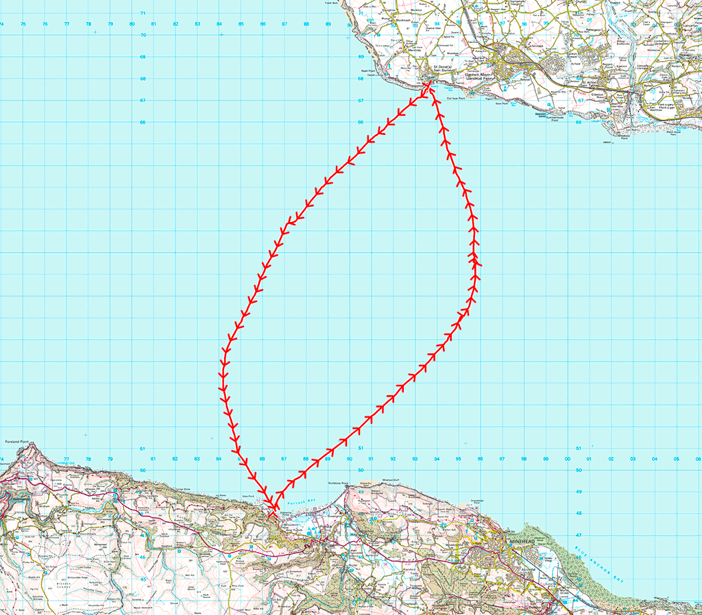
37 nautical miles (69 km) covered in just over 7.5 hours - channel riding at its best!

69 km round trip